Welcome Matrice Pilots!
Join our free DJI Matrice community today!
Sign up

Setting up Network RTK

Joined
Jun 22, 2021
Messages
13
Reaction score
0
Age
58
So I have watched the tutorial from DJI to setup RTK "custom network" but the missing link is identifying a service provider in North America. Contacted DJI directly but they said the service is only available in China. Has anyone used RTK without a base station via "custom network"?

Thanks.
 
To use Network RTK you will need:

An NTRIP or VRS Service. Some states offer this free, and there are also paid options. They will give you login credentials or even a configured SIM card that when placed in a hotspot or dongle will log you in to the service.

You could use an Emlid Reach RS2 as your base station placed on a known point, then use Emlid's free Caster application to send out corrections over NTRIP which the drone's controller can then connect to through the custom network option. This is what I use since there are no free services in my state and I have access to a secure known point from NGS.
Thanks J, do you use a sim card in the M300? If so, can you provide details?
 
No, I do not use a Simcard.

The manual for the Matrice 300 RTK does have a section on the remote controller. It shows how to place a DJI compatible Simcard dongle into the bottom of the controller. This will allow you to have 4G internet access where you can either place a 4G Simcard and gain internet access and then input your NTRIP or VRS service providers credentials (Given to you when you pay for or access a free service. Some states have free services through their state DOT).

Some NTRIP and VRS service providers can give you a Simcard that pretty much auto connects to the service.

I have not used the ways I just listed. I use an Emlid Reach RS 2 placed on a known point and then use Emlid's free Caster software to send out corrections over NTRIP. I then have a mobile hotspot that I connect my Matrice 300 RTK's controller to using Custom NTRIP. It works well.
 
Good information, thanks. One other question for you: when you set a mission to use ASL do you need to add altitude to ensure you are flying at X ft above sea level? For instance, I want to fly a mission at 100ft where the elevation at takeoff point is 200ft above sea level. Would I add that value to the estimated sea level, or will the drone figure out what I want to do?
 
No, I do not use a Simcard.

The manual for the Matrice 300 RTK does have a section on the remote controller. It shows how to place a DJI compatible Simcard dongle into the bottom of the controller. This will allow you to have 4G internet access where you can either place a 4G Simcard and gain internet access and then input your NTRIP or VRS service providers credentials (Given to you when you pay for or access a free service. Some states have free services through their state DOT).

Some NTRIP and VRS service providers can give you a Simcard that pretty much auto connects to the service.

I have not used the ways I just listed. I use an Emlid Reach RS 2 placed on a known point and then use Emlid's free Caster software to send out corrections over NTRIP. I then have a mobile hotspot that I connect my Matrice 300 RTK's controller to using Custom NTRIP. It works well.
I’m interested in your use of the Emlid Reach RS 2 and wondering how close the “known point” (you referred to) is to the area you are flying? I’m thinking you’re using the known point as a control point such as used in mappping. How do you confirm the geo location of your known points? What do you do if there are no known geo points in the area you fly?
 
I’m interested in your use of the Emlid Reach RS 2 and wondering how close the “known point” (you referred to) is to the area you are flying? I’m thinking you’re using the known point as a control point such as used in mappping. How do you confirm the geo location of your known points? What do you do if there are no known geo points in the area you fly?
To answer your first question, my known point can be any distance from my flight area since I am sending the corrections out over the internet as NTRIP, but you ideally want your corrections to be coming from a Base that is within 5 km. As distance increases so does possible error to the tune of 1mm for every km distance.

No, the known point is not a control point. The known point is where I setup my RS2 as a base. And as a base it needs to know its exact coordinates so that it can send out corrections either through NTRIP (Internet) or Lora (Long Rang Radio - Line out sight - For a rover to collect control points).


There are a few ways to obtain a known point.

The most accurate is to use an NGS monument with a low standard deviation.
Here is a link to the NGS map. National Geodetic Survey Data Explorer

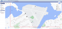
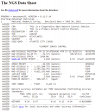
Here are screenshots of the map up close and an example of a monument with a low standard deviation and as a bonus uses Geoid 18 which is the newest geoid available.

Map of monuments
1656563050710.png

Monument Datasheet showing specifications.
1656563144046.png

This datasheet shows the coordinates in NAD83(2011) and an Ellipsoid, geoid and orthometric height.


Using the Emlid Reach RS2 in Base Mode, I would input the NAD83(2011) coordinates in from this monument (known point) and now my RS2 can send corrections out to a rover (either an RTK drone or another Emlid RS unit to collect control points).

You can use this monument to setup a new known point if you have another RS unit.


Another way to get a known point is to make your own. Find or place something in the ground that you can always find and reoccupy. (Rebar, spike etc.)
Place your RS2 on this point and log RINEX data for 10 hours.
Use Emlid's free Emlid Studio and its PPK (Post Processing Kinematics) workflow to obtain the coordinates for the point you are occupying. You would also need to download free CORS (Continually Operating Reference Station) RINEX logs for PPK.
or
take these RINEX logs and upload them to NGS OPUS Link: OPUS: the Online Positioning User Service, process your GNSS data in the National Spatial Reference System
OPUS will then email you the coordinates.


If there are no known points in the area, I will make my own using the above.

Don't forget to check with your state DOT as some states have free NTRIP access. I am in NJ and we do not have this luxury.

The Emlid RS2 has a lot of cool new features.
You can either send corrections over the internet through NTRIP (Need an LTE sim card or wireless Hotspot)
or
You can use their new Local NTRIP which has you connect the RS2 and your drone controller to the same wireless Hot Spot and then the RS2 sends NTRIP over this local Wifi connection (This has a limited range of 10 to 20 feet).
Emlid has its own PPK software for free, Emid Studio.
Emlid has Reachview 3 for collecting control points with a rover.
 
Good information, thanks. One other question for you: when you set a mission to use ASL do you need to add altitude to ensure you are flying at X ft above sea level? For instance, I want to fly a mission at 100ft where the elevation at takeoff point is 200ft above sea level. Would I add that value to the estimated sea level, or will the drone figure out what I want to do?
I do not want to answer your question incorrectly. I have yet to use ASL in a planned mission, but I would guess that yes you would have to set your altitude in your above scenario at 300 ft ASL. I use the Relative elevation based off of the barometer readings from the point where you took off from.
I still have to investigate a bit on ASL as I have been testing DJI Flight Hub2 recently and on its Project map, the listed elevation (orthometric) is totally incorrect for my area and is off by 5 meters. A use of a different geoid (EGM96 or Geoid 12 or 18) would not explain such a large discrepancy.
 
I managed to figure it out on a test flight yesterday. Basically, I had to add altitude by trial and error to get the drone to fly at 120m above takeoff point when using ASL. The reason I am using ASL is because I did a flight for a surveying company where my mission parameters were set to ALT (relative to takeoff point). When they looked at the exif data, they said the altitude was off by approximately 35-40m. When I switched to ASL in the mission, the results were the same - altitude in exif is way off. As shown below, the absolute alt is showing as 270m which is 150 ASL when you subtract the relative alt of the drone. The actual ASL according to google earth is 185m. I've checked some other sources to confirm google's data, and they show the same.

<drone-dji:AltitudeType>RtkAlt</drone-dji:AltitudeType>
<drone-dji:GpsLatitude>+43.874820435</drone-dji:GpsLatitude>
<drone-dji:GpsLongitude>-79.156146806</drone-dji:GpsLongitude>
<drone-dji:AbsoluteAltitude>+270.917</drone-dji:AbsoluteAltitude>
<drone-dji:RelativeAltitude>+120.000</drone-dji:RelativeAltitude>
 
Last edited:
I managed to figure it out on a test flight yesterday. Basically, I had to add altitude by trial and error to get the drone to fly at 120m above takeoff point when using ASL. The reason I am using ASL is because I did a flight for a surveying company where my mission parameters were set to ALT (relative to takeoff point). When they looked at the exif data, they said the altitude was off by approximately 35-40m. When I switched to ASL in the mission, the results were the same - altitude in exif is way off. As shown below, the absolute alt is showing as 270m which is 150 ASL when you subtract the relative alt of the drone. The actual ASL according to google earth is 185m. I've checked some other sources to confirm google's data, and they show the same.

<drone-dji:AltitudeType>RtkAlt</drone-dji:AltitudeType>
<drone-dji:GpsLatitude>+43.874820435</drone-dji:GpsLatitude>
<drone-dji:GpsLongitude>-79.156146806</drone-dji:GpsLongitude>
<drone-dji:AbsoluteAltitude>+270.917</drone-dji:AbsoluteAltitude>
<drone-dji:RelativeAltitude>+120.000</drone-dji:RelativeAltitude>

I am also having some issues in regards to the EXIF information.
I tested the Wide Camera on the H20T to produce a map in non-RTK mode and the elevations are shifted.
I even made my own elevations which I used for the images based on known information I obtained and there is still a large shift which cannot be explained due to barometer error.

I obtained my own elevations for the images by:
Finding the ellipsoid elevation from the point I took off from.
Used the Relative elevation from the image's EXIF.
Added the Ellipsoid elevation (-33.2 meters) to the Relative elevation of the images (40 to 45 meters)
Then rewrote the elevations to the EXIF of the images.

This still produced a large elevation shift in my map.
I then did something similar to above and applied the EGM96 Geoid and this then produced a large shift into the negative.

I will have to write to DJI to see what's up.

I did notice in Flight Hub 2 that the map DJI uses has ellipsoid elevations HAE that do not match up with other sources I have such as Arc Map Online Ellipsoid Height maps and also Google Earth.

This is the only drone I have ever been unable to produce a map with with good elevation data. Its a work in progress.

I do know that if I use either GCP Ground Control Points or turn on RTK this will fix this issue, but one should be able to not use RTK and still have elevations in the 2 to 10 meter error range instead of the 30 meter shift I am getting.
 

Members online

No members online now.

Forum statistics

Threads
2,717
Messages
25,373
Members
5,592
Latest member
Bigbair