Hi all,
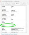
I have recently flown a survey mission with our Matrice 4E. But when I try to add GCP's to the job there is a 47M error between the drone data height and the GCP height I know the GCP's are correct.
The RTK height says it's at 0 this doesn't seem correct to me but I've never noticed it before and it's been fine on previous jobs before this last one which was just after a firmware update.
Any ideas on how to fix this would be appreciated.