

You are using an out of date browser. It may not display this or other websites correctly.
You should upgrade or use an alternative browser.
You should upgrade or use an alternative browser.
M4T RTK accurate or not ..
- Thread starter Mflyer
- Start date
No. Unfortunately the T version does not use Time Sync even when receiving corrections.
The mechanical shutter is not the main reason for the lack of accuracy/precision, it's the fact that DJI wants to make you buy both drones if you want to do thermal work and mapping by not having Time Sync on the T.
If you pause for each image you can get it tighter, but when flying a moving mapping grid flight, your horizontal will be the same as normal "GPS" only. The vertical is better and in tests I ran was within a meter for several maps.
You can always place GCPs to get your desired accuracy.

You probably could. In a Baamtech PPK kit for the Phantom 4 Pro v2, you actually used the drone to measure control points. You would place the drone on the target, have an X grid on the screen, line up the centerpoint with the center of the control point and take an image to trigger the PPK time stamp. This kit worked very well. They had measured the offset of the camera and the GNSS antenna.
If you are serious about mapping you would be better off investing in an Emlid or even the DJI RTK 3 receiver. You need to have check points regardless of having RTK/PPK to prove your accuracy. It seems like you already have a source of corrections so one receiver should work.
If you are serious about mapping you would be better off investing in an Emlid or even the DJI RTK 3 receiver. You need to have check points regardless of having RTK/PPK to prove your accuracy. It seems like you already have a source of corrections so one receiver should work.
Various places online have this debate. The problem is that not one person has ever produced an orthomap that includes check points to prove their accuracy. There are just claims of cm accuracy with the Matrice 4T, but they don't say whether this is relative accuracy (To scale, does 1 foot in my map measure one foot in reality) or absolute accuracy. Absolute accuracy is the placement of the map to the correct coordinates of reality.
The people saying it has cm accuracy are most likely referring to relative accuracy. When this becomes an argument I always ask to view the quality report showing the RMSE of the check points used. No one has ever posted this.
This debate has gone on since the Mavic 2 Enterprise Advanced came out with an RTK module. I own this drone and ran many tests while receiving corrections and the horizontal accuracy was the same as any drone that does not have RTK. The vertical though was usually around 1 meter or slightly below.
The Mavic 3E and 3T also had this debate.
Another problem is the large file size of the Matrice 4T and Mavic 3T's images. these large files slow down photogrammetry but do not offer better data.
The lack of mechanical shutter is also a problem although a lot of photogrammetry software do have algorithms to compensate for this.
Hmm interesting. Thank you for the detailed explanation and history of this ongoing topic 
This is valuable information in getting a good understanding about the product and it's (mis)information online.
The few tests I did was 10cm horizontal using webODM. Not sure if I done all software settings correctly but the 4T had fix all the time. Another ppk test with Emlid studio which showed 100% single in the photo's and reading your info, this could be because of the missing TimeSync?
Edit: Wait i'm mixing things up. Initially I was putting RTK/NTRIP files in Emlid Studio which is not correct for PPK so later I tested with normal files. The 100% single was however when I added the RTK/NTRIP files as a mistake for the PPK process.
Last edited:
A couple of questions.Hmm interesting. Thank you for the detailed explanation and history of this ongoing topic
This is valuable information in getting a good understanding about the product and it's (mis)information online.
The few tests I did was 10cm horizontal using webODM. Not sure if I done all software settings correctly but the 4T had fix all the time. Another ppk test with Emlid studio which showed 100% single in the photo's and reading your info, this could be because of the missing TimeSync?
Edit: Wait i'm mixing things up. Initially I was putting RTK/NTRIP files in Emlid Studio which is not correct for PPK so later I tested with normal files. The 100% single was however when I added the RTK/NTRIP files as a mistake for the PPK process.
When you say 10cm, what is reporting 10 cm?
Next, are you receiving corrections from an NTRIP service such as a CORS or paid service?
When using Emlid Studio are you uploading the obs, MRK and NAV files from your drone? And if so, what are you using for your base?
Here is what you can do.
You can use Emlid Studio.
GOto this site, NGS CORS and find the closest CORS station to where you flew a mission:
ArcGIS Web Application
 www.arcgis.com
Next you can download the required RINEX logs so you can PPK your data.
Make sure you download logs from the closest CORS for the same time period that your drone was flying. I always download 1 hour before and after to ensure I have the proper coverage.
Use Emlid Studio, use the drone's obs, and MRK files and then use the CORS obs and nav to PPK your data.
For the PPK process I used youtube from a respectable very helpful creator where I suspect you might be the same person ..
See attachment for the quality report. This was using the drone alone in FIX with RTK and NTRIP from a demo account which normaly is a paid service.

For PPK in Emlid Studio, I was indeed using the files from the drone (as was explained on youtube), and used the .o file from the RINEX data I requested from the provider. To my knowledge I can not use the CORS data from the website as I'm in Netherlands Europe?
See attachment for the quality report. This was using the drone alone in FIX with RTK and NTRIP from a demo account which normaly is a paid service.
For PPK in Emlid Studio, I was indeed using the files from the drone (as was explained on youtube), and used the .o file from the RINEX data I requested from the provider. To my knowledge I can not use the CORS data from the website as I'm in Netherlands Europe?
To see your real error for absolute accuracy, you need to add control points used as check points.
The above quality report is not able to properly assess absolute accuracy since the only data it has for absolute positioning is from the drone images which were used for processing. Alls it is doing is saying based on these coordinates from each image, the locations of the data created line up within this distance from where the software placed it and is assuming that the coordinates in each image is correct.
Check points are not used by the software when the software is creating the output. The check point when measured with a high end GNSS receiver, receiving corrections will give that control point known highly accurate coordinates that will only be used to "check" the accuracy and will not attempt to correct or shift any data. Think of it as you asking someone else for a second opinion, after the fact on how accurate the data is.
It's best practice is to prove accuracy with properly laid out and measured control points used as check points. And since you have to layout control points anyway, you could also lay out some GCPs to further tighten it up. Some projects could demand the use of check points, others may not. It's up to you and your clients to assess your needs.
You can further check accuracy if you are able to obtain accurate LiDAR data of the area you mapped. You can take your point cloud and the LiDAR point cloud and compare them in Cloud Compare, but the best practice method is to layout check points.
The thing about this whole debate on the Mavic 2 Enterprise Advanced, Mavic 3T and Matrice 4T in terms of are they cm accurate is that I have yet to find one test where a person laid out and collected check points and then assessed their accuracy using best practice. This debate has raged since 2021 when the Mavic 2 Enterprise Advanced came out, continued with the Mavic 3T and is still here with the Matrice 4T. It can easily be ended by one of the countless owners of these drones collecting check points and then showing the RMSE of the check points.
And no, I am not a content creator. I have though taught Remote Sensing in a Community College and learned how to properly drone map from a professional licensed surveyor who is a presence on various forums.
If you are able to, borrow or buy a GNSS receiver, use only control points used as check points, and post the results of 2 or 3 datasets and end this debate.
Very interesting topic; I'm precisely trying to confirm the accuracy of the M4T by creating an orthomosaic. Apparently, it's very accurate when connected via RTK through NTRIP using a caster in the region. Coincidentally, I'm in the same region as Mflyer look at RMS error attachment. Finally, when I have the results using QGIS and PDOK that confirm the accuracy, I will post them in the topic.
- Horizontaal (XY): ca. 2 - 3 cm
- Verticaal (Z): ca. 3 - 5 cm
Attachments
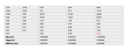

On the Pix4D quality report you are showing, that is the Geolocation section. Read the bottom of the page. "Note that the image geolocation errors do not correspond to the accuracy of the observed 3D points."
You need to have check points to assess absolute accuracy.
Your overlays show promise, but I am holding my judgement for a dataset checked against checkpoints. What is the accuracy of the layers you are comparing your data to?
Is there any chance you can borrow a GNSS rover and lay out some check points?
The debate will end soon, at least on my end. I am very close to getting a Matrice 4T. My Mavic 2 Enterprise Advanced takes images too slow and I have some possible upcoming jobs that may need the 4T.
If I do get the 4T I will make a map and cover the area with check points.
I want you guys to prove this.@Ro3go want to meet up to beat Jaja to it? :]
If interested, pls send me a direct message. We can discuss possibilities if you have a base station to plan check point or even GCP's.
Here is my persepctive on his results.
The limited data he gave showed that there was indeed a very nice alignment.
If the source data is absolute accurate data and his data lined up well, it is looking good. The chance that the source data is not accurate and his data is not accurate then lining up is not likely.
I called my vendor to ask if they ever made a map with check points with a Matrice 4T and he said no. But he said, that the Matrice 4t does use Time sync and that any inaccuracies would be from rolling shutter effect from not having a mechanical shutter.
My assumption has been based off of the 2 generations ago Mavic 2 Enterprise Advanced with RTK module not being accurate in the horizontal by meters. I fully tested this with 3 dataset. While the metadata did indeed have standard deviations listed for each image, the end result was measured in meters horizontal and about a meter vertical, with the vertical being about a meter in all datasets. It is fully possible that the Mavic 3T and Matrice 4T do in fact produce accurate results.
My skepticism is that in the last 3 years, I cannot find one dataset that has ever used check points from the 3T and 4T.
If this is true, I am even more likely to buy a 4T since I need the uprated thermal, but would have the side benefit of having a backup mapping drone. My current backup is a Phantom 4 RTK which does work well, but is aging rapidly.
Great respect for jaja6009 always contributing something positive to the forum.
What I'm trying to test is the accuracy of MT4, more than anything else, for my purposes it's quite reliable, and of course, this will depend on several factors.
I've been mapping large areas, taking 1,000 to 2,000 photos per mapping session with very precise RTK stability, without variations in the photos.
For this, I'm using an open database to confirm the accuracy. All the measurements agree, with differences sometimes of millimeters to one or two centimeters, which is within the margin of error.
Unfortunately, I don't have an RTK station, but I did create a GCP using MT4 as an RTK station and then correcting the antenna height. The results show a margin of error of 3cm to 8cm, which is what I would expect.
always contributing something positive to the forum.What I'm trying to test is the accuracy of MT4, more than anything else, for my purposes it's quite reliable, and of course, this will depend on several factors.
I've been mapping large areas, taking 1,000 to 2,000 photos per mapping session with very precise RTK stability, without variations in the photos.
For this, I'm using an open database to confirm the accuracy. All the measurements agree, with differences sometimes of millimeters to one or two centimeters, which is within the margin of error.
Unfortunately, I don't have an RTK station, but I did create a GCP using MT4 as an RTK station and then correcting the antenna height. The results show a margin of error of 3cm to 8cm, which is what I would expect.
I have changed my opinion on the M4T. I called one of my vendors and he stated that Time Sync is indeed running and the drone should produce low cm accurate data, and that error would come from rolling shutter effect.
Your testing is pointing in this direction.
I wish I was near you, I would lend you my GNSS rover so you could validate several sets of data.
I am very close to purchasing a Matrice 4T Dock version. I need a thermal solution that can take fast images, and I also need a solution with an IP rating.
Once I get this drone, I will fill an area with Check Points and then make some maps using just the drone's RTK and no GCPs.
If this works out like it looks like it will, I will have a solid backup mapping drone on top of a new thermal solution.
I just purchased a Matrice 4T. Is was a very hard decision between the dock version and the normal 4T. It has not shipped yet, but hopefully soon.
I will have a mapping competition between the Matrice 4E, Matrice 4T and the Phantom 4 RTK and post the results.
All drones will be receiving corrections via RTK and I will not have any GCPs. I will have 5 control points to assess the absolute accuracy.
Thanks to this threads participants for sharing their observations.
Congrats. Very curious about your findings !I just purchased a Matrice 4T. Is was a very hard decision between the dock version and the normal 4T. It has not shipped yet, but hopefully soon.
I will have a mapping competition between the Matrice 4E, Matrice 4T and the Phantom 4 RTK and post the results.
All drones will be receiving corrections via RTK and I will not have any GCPs. I will have 5 control points to assess the absolute accuracy.
Thanks to this threads participants for sharing their observations.
I hope the MT4 meets your expectations. In any case, the MTE is designed with greater precision for mapping, improving image quality, and I suppose its positioning will always be better.
I've now done a comparison between two types of flights. I processed the test flight you did (old station) to see the results. In the alignment, it's clear that the RTK correction isn't constant; it varies a lot. In my case, the value is always constant. I suppose something must be affecting your RTK connection. When you do the comparison tests between the two M4s, make sure the RTK is constant.

 Anyway, there's also a professional on YouTube who's done a comparison between the two M4s, but I still think there could be variations depending on the location and circumstances. Here are two screenshots of the Relative Geolocation Variance report, both yours first one and mine second one.
Here's the link if you want to watch it. It's in Portuguese, but you can change the audio... You should add this to youtube homepage: /watch?v=rpS_hVruALc
I'm curious to know the results and whether they meet expectations.
I've now done a comparison between two types of flights. I processed the test flight you did (old station) to see the results. In the alignment, it's clear that the RTK correction isn't constant; it varies a lot. In my case, the value is always constant. I suppose something must be affecting your RTK connection. When you do the comparison tests between the two M4s, make sure the RTK is constant.
Anyway, there's also a professional on YouTube who's done a comparison between the two M4s, but I still think there could be variations depending on the location and circumstances. Here are two screenshots of the Relative Geolocation Variance report, both yours first one and mine second one.Here's the link if you want to watch it. It's in Portuguese, but you can change the audio... You should add this to youtube homepage: /watch?v=rpS_hVruALc
I'm curious to know the results and whether they meet expectations.
Similar threads
- Replies
- 6
- Views
- 2K
- Replies
- 1
- Views
- 3K
- Replies
- 0
- Views
- 3K
- Replies
- 0
- Views
- 3K
