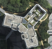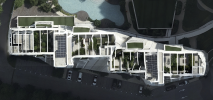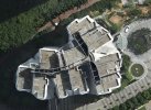
I used DJI M300 for top down scanning/mapping for a neighbourhood which consist of high rise buildings and landed buildings. The drone is flying in a zigzag pattern route during the mapping process. I create a 2D photogrammetry map from the photos captured. However, i noticed there are some obvious misalign and distorted on the high rise buildings rooftop, either with the smart oblique on or off, the same issue still happens. For contexts, i was flying at 400m and the buildings are roughly 150m to 180m tall, and using zenmuse P1 payload with 50mm lens. Is there any ways to prevent this to happen?

Misalignment in buildings when mapping
- Thread starter jyk
- Start date
-
- Tags
- m300 mapping matrice 300