Welcome Matrice Pilots!
Join our free DJI Matrice community today!
Sign up

Matrice 4E "Smart Oblique" Processing Problems

Joined
May 15, 2025
Messages
2
Reaction score
0
Age
44
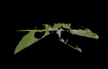
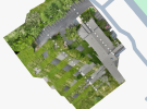
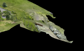
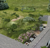
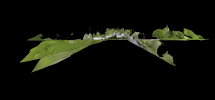
Recently received new Matrice 4E for use in AEC work. M4E purchased with the intent of increasing the use of 3D models in design and project acquisition. While experimenting with the UAV I have gathered multiple data sets to see what it turns out. When using the smart oblique setting on an "area" mission the processed data came back as complete trash. Anyone seen results like what I have attached below? What was your solution?
 

Attachments

  • Screenshot 2025-05-20 084205.png
    Screenshot 2025-05-20 084205.png
    200.8 KB · Views: 14
  • Screenshot 2025-05-20 101833.png
    Screenshot 2025-05-20 101833.png
    1.4 MB · Views: 14
I have had similar results with 1 of 3 tests projects that I have flown. All using ortho collection with smart oblique on. The only difference so far is I had 70% side overlap on the failed map and 80% on the two that turned out well. I tried multiple settings in Terra thinking it was Terra with same results. I thought it was Terra because WebODM turned out great with the same data. I'm going to fly the same failed mission again tomorrow with 80% side overlap and see how that map turns out in Terra.
 
Was able to fly the failed map mission again and only changed the side overlap to 80 instead of 70 and raised the flight altitude by 4 feet to cut down on number of photos needed. This time the map and model turned out well.


1748134813755.png1748134955008.png


1748134633228.png1748134701612.png
 
What altitudes were you flying?
While I have used the Smart Oblique setting with success, I still mostly use my tried and true oblique double grid at 200 to 250 ft AGL for terrain. I might dip down to 150 occasionally.

Sometimes too many images is not good, especially when not using RTK and when using more extreme oblique angles.

Glad you figured it out. Photogrammetry is as much of an art as a science. Every area you map may have its own problems you will have to account for in terms of altitude, overlap and image collection scheme.
 
I have been flying as low as I can for the best quality vs photo count. That was a small area so I flew at 70' height to keep the photo count under 400 for processing time.
The failed map was at 66' but when I raised the side overlap to 80 the picture count was almost 500 photos so I raised to 70' to cut down on processing time. I know on larger jobs I will definitely have to fly a lot higher.
I figure each job will be an adjustment of height and overlap to keep the job at a processing time your looking for as well as quality.
The low altitude was most likely why the original failed.
I like models to have ultra low GSD for building inspection purposes.
For terrain though 1 cm GSD is good.

Thanks for sharing as this will help others out!
 

Members online

No members online now.

Forum statistics

Threads
2,886
Messages
25,982
Members
5,946
Latest member
Krc64