- Joined
- Mar 7, 2021
- Messages
- 3
- Reaction score
- 0
- Age
- 45
Hello
Basically we are a small surveying company, we do LiDAR surveying work, most of it in hilly terrain, we work in Latin America mostly where the FAA does not exist.
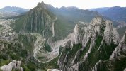
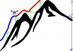
The problem we have is when we try to survey mountain slopes we never fly over 50-80m AGL, always in line of sight, with permits, and always complying with applicable legislation, the problem is from where we take off to where we need to get to the drone locks at 500m (see image), while it may sound like a lot, its not, working in this kind of terrain (see picture) a 500m difference in height can be as close as 150m in front of you.
There's no planes or people here, its barren dessert canyons, no risk to anyone or anything.
We've tried explaining this to DJI but well yeah you know how that went.
Since we are a business, we do have legal authorization to fly (we fly larger birds like the Terrahawk CW-30 for these kind of missions) but chose not to here for obvious reasons, the canyons are too steep and the $$$ danger too great.
Were tired of wasting our time and decided to bite the bullet, we just bought another M600 with the sole purpose of making sure we CAN fly higher than 500m what ever it takes for these kinds of situations.
Since were we are now no laws are being broken, does anyone know what options are there??
CopterSafe looks legit, but send me $700 worth of bitcoin, with no phone, address or email and hope for the best while their last post was on 2017 does not inspire any confidence. there's another Skyhack ru that's all Russian (apparently they don't speak English) but at least it has a phone number.
Were desperate here, we have a business to run and we bend over backwards to comply with all local legal legislation but DJI just doesn't care. we've been climbing up the hills carrying the drone on a backpack as a workaround to this stupidity but after our second snake bite in a week we've had enough.
Anyone know any options we can use to fix this? if you tell me to bite the bullet on CopterSafe ill do it, we just want to at least do some due diligence before sending $700 to a Nigerian prince
And I'm sorry if this post breaks any forum rules, I did search and found there are other posts with similar questions regarding other models so I assumed it would be ok to ask, if not I'm sorry, we just don't know where else to go.
Thank you all for your help in advance.
Basically we are a small surveying company, we do LiDAR surveying work, most of it in hilly terrain, we work in Latin America mostly where the FAA does not exist.
The problem we have is when we try to survey mountain slopes we never fly over 50-80m AGL, always in line of sight, with permits, and always complying with applicable legislation, the problem is from where we take off to where we need to get to the drone locks at 500m (see image), while it may sound like a lot, its not, working in this kind of terrain (see picture) a 500m difference in height can be as close as 150m in front of you.
There's no planes or people here, its barren dessert canyons, no risk to anyone or anything.
We've tried explaining this to DJI but well yeah you know how that went.
Since we are a business, we do have legal authorization to fly (we fly larger birds like the Terrahawk CW-30 for these kind of missions) but chose not to here for obvious reasons, the canyons are too steep and the $$$ danger too great.
Were tired of wasting our time and decided to bite the bullet, we just bought another M600 with the sole purpose of making sure we CAN fly higher than 500m what ever it takes for these kinds of situations.
Since were we are now no laws are being broken, does anyone know what options are there??
CopterSafe looks legit, but send me $700 worth of bitcoin, with no phone, address or email and hope for the best while their last post was on 2017 does not inspire any confidence. there's another Skyhack ru that's all Russian (apparently they don't speak English) but at least it has a phone number.
Were desperate here, we have a business to run and we bend over backwards to comply with all local legal legislation but DJI just doesn't care. we've been climbing up the hills carrying the drone on a backpack as a workaround to this stupidity but after our second snake bite in a week we've had enough.
Anyone know any options we can use to fix this? if you tell me to bite the bullet on CopterSafe ill do it, we just want to at least do some due diligence before sending $700 to a Nigerian prince
And I'm sorry if this post breaks any forum rules, I did search and found there are other posts with similar questions regarding other models so I assumed it would be ok to ask, if not I'm sorry, we just don't know where else to go.
Thank you all for your help in advance.