Welcome Matrice Pilots!
Join our free DJI Matrice community today!
Sign up

Creating 2D orthomosaics with an M30T

Joined
May 16, 2022
Messages
6
Reaction score
3
Age
63
I'm 'pinch hitting' for a school organization that is looking to create a series of orthomosaics over time. Probably about a dozen per year I imagine. They involve various sports fields that have been marked up, etc for a competition.
While accuracy is not very important, the final resolution of the ortho is. This would be 2D only.
I tried using photoshop and just stitching together images from 200' with my M30T. It worked great, but the resolution wasn't as high as I was hoping for.
I then brought the AGL down to 92' (about 1cm/pixel) and the resolution seems to be exactly what I'm looking for.
However, photoshop blew up at about 150 12MP images, even with 256GB RAM.
I started looking at specific Mapping software and several trials: Pix4D, Agisoft Metashape, Mapsmadeeasy, Mapware, OW and some others. All of them could handle the 400 or so images I capture per ortho, but they pretty much all seem like overkill? Plus, most are way too expensive for someone like me that is just helping a school out. There's zero money in this.

THE QUESTION:
What other apps or tools do you think I should consider?

I'm looking for a simple "panorama stitcher" that can handle at least 400 12MP images. I don't need point clouds or any complexity. Just stitch it with little to no distortion. ie: A football field will still be rectangular after being stitched..
My last resort might be to run several missions of 100 images each and then assemble them in PS myself if I can't find an alternative..

Thanks!
 
  • Like
Reactions: GsquaredAerials
I'm 'pinch hitting' for a school organization that is looking to create a series of orthomosaics over time. Probably about a dozen per year I imagine. They involve various sports fields that have been marked up, etc for a competition.
While accuracy is not very important, the final resolution of the ortho is. This would be 2D only.
I tried using photoshop and just stitching together images from 200' with my M30T. It worked great, but the resolution wasn't as high as I was hoping for.
I then brought the AGL down to 92' (about 1cm/pixel) and the resolution seems to be exactly what I'm looking for.
However, photoshop blew up at about 150 12MP images, even with 256GB RAM.
I started looking at specific Mapping software and several trials: Pix4D, Agisoft Metashape, Mapsmadeeasy, Mapware, OW and some others. All of them could handle the 400 or so images I capture per ortho, but they pretty much all seem like overkill? Plus, most are way too expensive for someone like me that is just helping a school out. There's zero money in this.

THE QUESTION:
What other apps or tools do you think I should consider?

I'm looking for a simple "panorama stitcher" that can handle at least 400 12MP images. I don't need point clouds or any complexity. Just stitch it with little to no distortion. ie: A football field will still be rectangular after being stitched..
My last resort might be to run several missions of 100 images each and then assemble them in PS myself if I can't find an alternative..

Thanks!
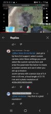
I can't seem to find it right now, but I saw YouTube video that allows you to use the high-resolution 48 megapixel camera on the m30t for mapping. You have to select other camera and then set the resolution. It looks pretty cool and it was definitely high resolution maps. I want to try that with mine as well (as soon as I get it replaced).

I just found the screen capture. Hopefully it attaches here properlyScreenshot_20220824-231052_YouTube.jpg
 
I'm 'pinch hitting' for a school organization that is looking to create a series of orthomosaics over time. Probably about a dozen per year I imagine. They involve various sports fields that have been marked up, etc for a competition.
While accuracy is not very important, the final resolution of the ortho is. This would be 2D only.
I tried using photoshop and just stitching together images from 200' with my M30T. It worked great, but the resolution wasn't as high as I was hoping for.
I then brought the AGL down to 92' (about 1cm/pixel) and the resolution seems to be exactly what I'm looking for.
However, photoshop blew up at about 150 12MP images, even with 256GB RAM.
I started looking at specific Mapping software and several trials: Pix4D, Agisoft Metashape, Mapsmadeeasy, Mapware, OW and some others. All of them could handle the 400 or so images I capture per ortho, but they pretty much all seem like overkill? Plus, most are way too expensive for someone like me that is just helping a school out. There's zero money in this.

THE QUESTION:
What other apps or tools do you think I should consider?

I'm looking for a simple "panorama stitcher" that can handle at least 400 12MP images. I don't need point clouds or any complexity. Just stitch it with little to no distortion. ie: A football field will still be rectangular after being stitched..
My last resort might be to run several missions of 100 images each and then assemble them in PS myself if I can't find an alternative..

Thanks!
Hi, just checking if you found a solution here? I also need to make simple ortho's for the purpose of counting marine turtle tracks. Which of the software you've tried would you suggest? Thanks
 
WebODM. instead of the expensive DD and others, you pay by usage, and its very reasonable. It doesn't support DJIs RJPGs, but for photos its fine. Ive heard of some people converting the RJPG formats and having success, but i was never able to do so.
 

Members online

Forum statistics

Threads
2,727
Messages
25,387
Members
5,600
Latest member
RomanChrz