Welcome Matrice Pilots!
Join our free DJI Matrice community today!
Sign up

Base station - rtk/ppk

Joined
Mar 25, 2025
Messages
6
Reaction score
0
Age
49
Hi,
I’m new to photogrammetry, struggling to get my head around a few things and would like some advice please.
I have a Matrice 4E, a D-RTK 3 base station and access to ntrip corrections.
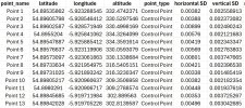
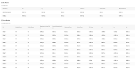
What would be the most suitable way to incorporate all of the above to provide the most accurate surveys? Struggling to get my head around RTK/PPK processing as all of my surveys are out by around a metre at least. I record GCPs using the D-RTK 3 as a rover (using ntrip corrections), I then use the D-RTK 3 as a base station, connect my drone and fly the mission. Maybe it’s something I’m doing wrong at the processing part. Confused.com!!
Thanks for any help provided.
 
You have everything you need. You just have to put together a workflow.

First.

You have correctly connected the DRTK to the NTRIP service? ( I use Emlids so I cannot help you there.) But, do you know what datum your NTRIP service gives its corrections in? In the US, most will send corrections in NAD83 (2011) and use ellsipsoid for elevations.

You state the GCPs are out by a meter? For better communication, lets call them Control Points. Are these Control Points used as GCPs or as Check Points?

What software are you using for processing? I am assuming Terra, since you got a free subscription with you M4E purchase.
I use Agisoft, but might be able to help with Terra.
You state a meter inaccuracy. Is this meter an average for all Control Points? This sounds like a datum transformation issue.

There are a lot of other questions, but these will make a good start.
 
Wow, thank you for your quick response. I record Control Points with a rover using ntrip and standard deviation errors horizontally and vertically are in the 0.006m which I’m very pleased with. I then use the base station with the same ntrip corrections to fly the mission. It’s when I process all info in Terra, the resulting ortho map is out by a metre. For example, if I obtain coordinates from any given point on my ortho map and check them against Google Earth Pro, I am out by at least a metre. I guess it’s how I’m importing the Ground Control data and processing data. Note: 10 points over the site recorded. 5 used as Control Points and 5 used as check points.
 
Are you saying that when comparing a point on your Terra created map, it disagrees with Google Earth by a meter?

If so:

1. Google Earth's coordinates are not survey grade.
2. Google Earth's coordinates are in WGS 84, and most projects in the US want to use NAD83 (2011) and a projection with State Plane being the most common.

To assess your maps accuracy, you do so by the RMSE of the Check Points. If you want to compare against another map, make sure the map used is in the same datum and also is of a high accuracy.

I would start off by knowing what datum your NTRIP provider sends corrections in. If in the US, a good assumption is NAD83 (2011) with ellipsoid elevations. I am unfamiliar with DRTK as I use Emlid GNSS units. Give me the elevations of your collected control points.

I cannot help you with Terra on DTRK as I use Agisoft Metashape Pro and Pix4D matic and mapper. But I can help you understand datums, coordinate systems and geoids.

Finally what is your output datum and projection?
 

Recent Posts

Members online

No members online now.

Forum statistics

Threads
2,848
Messages
25,846
Members
5,884
Latest member
JerryUAVO