- Joined
- Jun 22, 2021
- Messages
- 13
- Reaction score
- 0
- Age
- 60
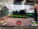
I noted in a recent test that the "absolute altitude" is being calculated based on the equation: ellipsoidal height + relative altitude, whereas one would expect the equation: ASL + ALT (relative altitude). In the example below, ASL is shown to be 115.2m and ALT is shown at 0.0 (i.e., the drone is on the ground - see File1.jpg).
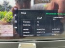
The exif for a sample image from this position, does not reference ASL at all (assumption is that it should). Instead the exif combines ellipsoidal height + ALT (relative altitude) which in the case of the sample provided is 78.28m + 0.0 (see File2.jpg). My assumption was that absolute altitude should be shown as ASL + ALT (relative altitude). In this case, that would be 115.2 + 0.0 = 115.2.
The reason this has come up is that a survey client noted the altitude readings in the image files provided were way off. Does anyone have any experience with this situation?
Relevant section of exif:
<drone-dji:Version>1.4</drone-dji:Version>
<drone-dji:GpsStatus>RTK</drone-dji:GpsStatus>
<drone-dji:AltitudeType>RtkAlt</drone-dji:AltitudeType>
<drone-dji:GpsLatitude>+43.864457302</drone-dji:GpsLatitude>
<drone-dji:GpsLongitude>-79.087884133</drone-dji:GpsLongitude>
<drone-dji:AbsoluteAltitude>+77.982</drone-dji:AbsoluteAltitude>
<drone-dji:RelativeAltitude>+0.000</drone-dji:RelativeAltitude>


